-
.png) Himalayas on the way to Everest Base Camp
Himalayas on the way to Everest Base Camp
Nepal Travel Guide
-
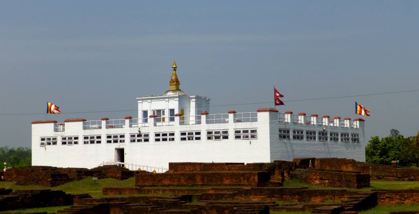 Lumbini
 -
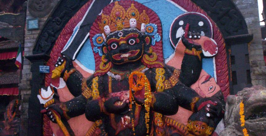 Karo-Bairabat Kathmandu Durbar Square
 -
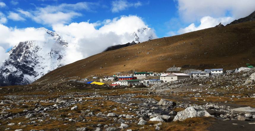 Loboche village
VISITING NEPAL: Travel Guide
Nepal Facts
Official name: Federal Democratic Republic of Nepal
Capital: Kathmandu
Demonym: Nepalese
Population: 28.98 million (2016) World Bank
Capital and largest city: Kathmandu; 27°42′N 85°19′E / 27.700°N 85.317°E
Area: 147,181 km2
Official languages: Nepali
Climate: Nepal has different weather extremes. From high peaks, Down to the tropical plains. Height and environment are important factors of weather. The southern area is in the tropics, warm and humid the average daytime temperature is 37 degrees Celsius, while the lowest winter temperature is 8 degrees Celsius. The Eastern area is alpine, more than 3000 meters high. The temperature ranges from 16 degrees Celsius to -6 degrees Celsius. The central part is cool, between 28 ° C and -2 ° C.
Kathmandu Capital At an altitude of 1300 meters, the temperature is warm in summer. And the cool weather in winter, October to March, suitable to visit. Pokhara has a warmer climate than Kathmandu. The temperature at noon can be as high as 30 degrees Celsius in the winter. Nepal has four climatic seasons.
Spring (March-May), the temperature is mildly warm in low lands while moderate in higher altitudes. It is also the time for flowers to blossom and the national flower of Nepal – Rhododendron sweeps the ascending altitudes with its magnanimous color and beauty.
Summer with the moon soon (June – August), the weather is hot and wet at times. It rains almost every day. The rain spreads the pleasantness around with lush green vegetation.
Autumn (September – November), this is the best tourist season in Nepal with the summer gone by and the winter to set in. The weather is highly pleasant so are the mountain views. This is the peak season for trekking as mountain views.
Winter (December –February): The weather is cool and the sky is clear with occasional snowfalls at higher elevations. The morning and night are cold and the days are warm when sunny.
Here’s a brief view of the average temperatures and rainfall during peak summer and winter in three most popular tourist areas:
|
Place |
Summer (May, June, July) |
Winter (Dec, Jan, Feb) |
||||
|
Max (°C) |
Min (°C) |
Rain (mm) |
Max (°C) |
Min (°C) |
Rain (mm) |
|
|
Kathmandu |
28.1 |
19.5 |
312 |
19.3 |
3.0 |
15.4 |
|
Pokhara |
29.7 |
21.3 |
829.7 |
20.3 |
7.7 |
26.3 |
|
Chitwan |
33.0 |
25.3 |
404.0 |
24.1 |
8.3 |
13.8 |
For more information about Nepal’s climatic condition please visit the official web site of the Department of Hydrology & Meteorology, Ministry of Environment.
Location: Nepal is located in the central part of the Asian Continent. Geographically it extends from 26 degrees 22'N to 30 degrees 27'N latitude in the northern hemisphere and from 80 degrees 4' E to 88 degrees 12'E longitude in the eastern hemisphere.
Language: The official language of Nepal is Nepali, formerly called Khaskura then Gorkhali. Most belong to the Indo-Aryan and Sino-Tibetan language families. According to the 2011 national census, the percentage of Nepali Bhasi people is about 44.6%. Maithili is the second largest Nepalese language and according to 2011 Census, the percentage of Maithil people is 11.57%.
Time: Areas with same time currently (UTC +5:45). Currently has the same time zone offset as NPT (UTC +5:45) but different time zone name. Nepal Time (NPT) is 5:45 hours ahead of Coordinated Universal Time (UTC). This time zone is in use during a standard time in Asia.
Religion: Nepal has the people of different religious tolerance among the people. However, the people who follow Hindu religion are in great number. Besides this, Buddhism is another popular religion of Nepal. There are many followers of Islam, Christianity, Shikhism, Jainism and Kirat religion.
|
Hinduism |
86.51% |
|
Buddhism |
7.78% |
|
Islam |
3.53% |
|
Christianity, Tantrism & others |
2.17% |
Units of measurement: The Nepal country has the metric system as its official standard units pertaining to length (specifically inch and foot) and metric units such as kilogram and liter are also fairly common in everyday trade and commerce.
Money: Nepalese Rupee (NPR)
Electricity: In Nepal, electricity runs on 220/240 volts. Nepal electric Plugs are of two or three round prongs and flat prongs are also available in multi-plugs and extension cords.
Communications: Travelers can easily purchase a SIM card as well as data. And it’s quite affordable. Nepal had 2 companies for the SIM card it is Ncell and Nepal Telecom. The general consensus is that Nepal Telecom has slower speeds but greater coverage in the mountains, while Ncell is faster and easier to set up for foreigners.The Most hotels provide internet service or free WIFI. Restaurants, cafes, and tea houses also have free WIFI. There are dozens of internet cafes in Kathmandu.
If you’re planning on spending significant time in the mountains and want better (although far from guaranteed) coverage, consider picking up a Nepal Telecom SIM card as well – if you can get your hands on one.
Accommodation: Nepal has a huge range of options. From cheap, basic rooms for backpackers to much nicer hotels, some eco-lodges and a luxury five-star resorts and fun things like tea houses and such.
Passport and Visa Information: Your passport must be valid for at least six months with 2 photos of passport size and you will need a whole free page for your visa. Visas are available on arrival at the international airport in Kathmandu and at all land border crossings that are open to foreigners. The visas fee pay in foreign currency (some crossings insist on payment in US dollars). Nepal issues visas on arrival for citizens of most countries. These can be purchased for 15, 30, or 90 days and range from $25 to $100. Volunteers technically require a visa arranged by the place they are working with as volunteering on a tourist visa is expressly forbidden, though harder for them to enforce.
Food: Nepal has food habits different depending on the region. The regular Nepali meal is Dal (lentil soup), Bhat (plain rice) and Tarkari (curried vegetables), often accompanied by Achar (pickle), Curried meat is saved for special occasions, as it is relatively more expensive. Momos (steamed or fried dumplings) deserve a mention as one of the most popular snacks among Nepalese. Nepali food has been influenced by Indian and Tibetan styles of cooking. Authentic Nepali taste is found in Newari and Thakai cuisines. Most Nepalese eat with their right hand.
Festivals of Note: Phalgun Festivals, Kathmandu (Feb/March). Dashain, country-wide (September/October). Indra Jatra, Kathmandu (September) get the detail of festivals in Nepal here.
Entering to Nepal:
By Land: Nepal had three sides’ borders with India the entry points are are Kakarbhitta, Birgunj, Belhiya, Bhairawa, Nepalgunj, Dhangadi and Mahendra Nagar. And one side’s border with Tibet (China) on the north it is Kodari. Tourists entering Nepal by land must also carry their passports.
By Air: Tribhuvan International Airport (TIA) is the only gateway to Kathmandu for the tourists who come by air. The Airport named after King Tribhuvan, the 8th Shah King of Nepal, is situated about 4.5 miles east of the city (about 25 minutes’ drive). TIA is also in between all the three major cities of Kathmandu Valley namely Kathmandu, Bhaktapur, and Patan. Facilities of the bank, duty-free shop, restaurants, and tourist information center is available at TIA.
When to Go: You’ll need to plan your visit around your planned activities. If you’re hiking, the trails are closed during monsoon season, which runs from June through August. Trekking season is September through May. Autumn and spring are beautiful; lush and green in the fall and flowering and cool in the spring. Winter can be chilly at altitude but is pleasant in the Kathmandu Valley.

- We love to talk adventures, speak to one of our trekking experts now!
- +977 9841326314
Plan what to do in Kathmandu with an itinerary including Thai Nepal Travels and Tours